Norse settlement in Vatnahverfi, South Greenland
ca. AD 985 – 1450
By Jette Arneborg
Introduction
The Southwest Greenland fjords were settled from Iceland around AD 985. The settlers established themselves in two main areas, in The Eastern Settlement in nowadays Nanortalik, Narsaq and Qaqortoq municipalities and in The Western Settlement in the Nuuk region. The settlements were abandoned around 1450 for reasons not yet fully understood. Research has in the resent years concentrated on the impact of climatic and environmental changes in the settled areas. Within the project Resources, Mobility and Cultural Identity in Norse Greenland the aim of the Vatnahverfi-project is to discuss the interrelation and mutual influences between environmental factors and human social and economic strategies.
The multi-site landscape of Vatnahverfi in the centre of The Eastern Settlement was rather densely built-up in the Middle Ages, and it holds farms of different size and status, probably broadly representative of the Norse Greenland society. Today modern Greenlandic sheep farmers have revived farming in Vatnahverfi and they are facing some of the environmental challenges, as did the Norse. The landscape links past and present, and another aim of the project is to identify and communicate past events to the present users.
"Stand der Forschung"
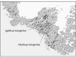
According to the Book of Settlement the Icelandic settler Hafgrímur took land in Hafgrímsfjörð and Vatnahverfi. This was in the late 980s. Vatnahverfi is only mentioned this once, still it is the only Norse place name that has survived on modern maps. Vatnahverfi means a settled area with freshwater lakes and has been identified with the many Norse ruins that are located between Alluitsup kangerlua and Igalikup kangerlua. Vatnahverfi covers an area of more than 500 square kilometres.
To the northwest Vatnahverfi is bounded by Igalikup kangerlua, to the southeast the inland ice. The landscape is mountainous with rich vegetation along the coast, on the lakes and in the valleys. The Jespersens glacier is a pronounced feature and central to environmental events in the region. In periods strong southeastern gales ravage the landscape, and archaeological excavations have revealed that erosion was a great challenge to several Norse farmers in Vatnahverfi.
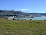
The large high status farm Ø66 in Igaliku Kujalleq was the social and economic centre of the region. The public church was here and foreign traders called in when on their infrequent visits in Greenland. The remains of older churches at the farms Ø64 in the northern part of Vatnahverfi and Ø78 in the southern part point at an earlier social structure that may have been more egalitarian.
Apart from large Ø66 farm the late period farms in Vatnahverfi were middle sized to small. Sheep and goats were the dominant domesticates although marine resources, primarily seals were very important to the economy as well.
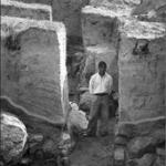
The archaeology of Vatnahverfi is closely associated with Danish archaeologist C.L. Vebæk who put a lot of work into especially Vatnahverfi. Vebæk first expedition to Vatnahverfi took place in 1939, and he returned immediately after World War III. Vebæk was the first to excavate inland Vatnahverfi farms. Before him the Norwegian Aron Arctander recorded Norse ruins in Vatnahverfi in the 1770s, as did naval lieutenant Gustav Holm in 1880 and first lieutenant Daniel Bruun in 1894.
After the SILA surveys in 2005 and 2006 436 ruins have been recorded in Vatnahverfi. The many ruins are spread on 81 sites. Niels Algreen-Møller and Christian Madsen – both archaeology students at the University of Copenhagen - carried out the SILA surveys.
Project objectives
How did the Norse settlers adapt to and live in the landscape the settled, and how did the dynamic environment and changing conditions influence the community and the social and economic strategies and decisions taken?
Methods
Evaluation of former archaeological investigations.
New GPS-survey of all Norse ruins in the Vatnahverfi region.
Small-scale archaeological excavations at selected sites to get samples for an AMS-dating programme and economic and environmental samples.
GIS based high resolution landscape modelling.
Planning
2007: Small-scale archaeological excavations at selected sites to get material for dating and zoo- & other eco-archaeological studies.
International collaboration
The SILA-project Resources, mobility, and cultural identity in the North Atlantic - The Norse Settlement in the Vatnahverfi region, South Greenland ca. AD985 – 1450 takes part in international and interdisciplinary research networks:
MARENA – Marine resource exploitation in the North Atlantic submitted to and endorsed by the IPY 2007/08 (International Polar Year) international committee. The Vatnahverfi-project is the Greenland contribution to the project. Lead. Professor Orrí Vesteinsson, University of Iceland.
Islands Connections: Integrative Multi-scalar Historical Ecology in Faroes, Iceland, and Greenland. The project is a supplement to the MARENA-programme with the purpose to gain a better understanding of regional-scale questions by linking field and laboratory investigations in the three North Atlantic Islands. Lead: Professor Thomas McGovern, Hunter College, New York.
Landscapes circum Landnám. Lead: Professor Kevin Edwards, Aberdeen University. 2002 – 2006. Founded by the Leverhulme Trust. Environmental research has among other taken place in the Vatnahverfi region.
Footprints on the Edge of Thule: landscapes of Norse-indigenous interaction. Lead: Professor Kevin Edwards, Aberdeen University. 2007 – 2011. Founded by the Leverhulme Trust. Environmental research in the Vatnahverfi region.
Reports
Algreen Møller, Niels & Koch Madsen, Christian (2005) Nordboerne i Vatnahverfi. Rapport om rekognoscering og opmåling af nordboruiner i Vatnahverfi, sommeren 2005. SILA Feltrapport nr. 24.
Algreen Møller, Niels & Koch Madsen, Christian (2006) Gård og Sæter, Hus og Fold - Vatnahverfi 2006. Rapport om besigtigelser og opmålinger i Vatnahverfi, sommeren 2006. SILA Feltrapport nr. 25.
Algreen Møller, Niels (ed.); Lund Johansen, Louise; Koch Madsen, Christian; Felding, Louise; Baltzer Heide, Poul & Smiarowzki, Konrad (2007) Udgravninger af norrøne kirkergårde og møddinger. Rapport om opmålinger og udgravninger i Vatnaverfi, sommeren 2007. SILA Feltrapport nr. 26.