The GeoArk Project 2003-2009
Cultural History, Climate and Environment in Holocene North East Greenland
Background of the interdisciplinary Geo-Ark program
The Geo-Ark Project is an interdisciplinary project between the Humanities, represented by researchers from SILA - The National Museum of Denmark, and the Natural sciences, represented by researchers from Institute of Geography and Geology, University of Copenhagen and the Zoological Museum, SNM, University of Copenhagen. The project is part of the IPY-program: ‘Dynamic Social Strategies in Arctic Environments. The Geo-Ark project is financed by the Danish Ministry of Science, Technology and Innovation.
Inuit and their ancestors, the Palaeo- and Neo-Eskimos, have migrated into, colonized and abandoned North East Greenland at least four times during the last four millennia. However, the environmental, cultural, and demographic variables and their delicate interplay, which sporadically opened 'windows' for these discontinuous settlement episodes, have formerly received little attention.
.")
The GeoArk-project is established as an interdisciplinary research program exploring the dynamics of the High Arctic environment - climate, coasts, natural resources - and the cultural strategies applied by the native cultures of North East Greenland in order to cope with ever-changing life conditions. GeoArk is an integral part of the endorsed IPY-initiative # 6: ‘Dynamic Social Strategies in Arctic Environments’.
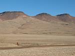
During the IPY-years, 2007-2009, the GeoArk-project focuses on the era during which the Thule Culture migrated into and settled North East Greenland, from about 1400 AD to 1823 AD, when Europeans for the first and last time encountered Inuit in this part of Greenland. The Thule Culture era of 400 - 500 years provides splendid possibilities to elucidate the objectives of the general IPY-program.
The Key Issues GeoArk aims at elucidating important and complex cultural historical and environmental problems, which must be approached via an interdisciplinary framework. Thus, researchers from the humanities (archaeology/history) and natural sciences (geo- and biosciences) collaborate across disciplinary borders in order to answer the following questions:
Which environmental and cultural preconditions favoured the initial Thule Culture colonization of the High Arctic during the first part of the 1400s AD after probably more than 1500 years of desolation?
Which factors – including environmental and/or external cultural changes like European commercial whaling and sealing – and native cultural strategies triggered the disappearance of the Thule Culture in North East Greenland during the first half of the 19th century?
Which were the key game species of the Thule Culture, and how were their distribution and availability linked to climatic fluctuations, sea ice conditions, snow coverage on land, and other dynamic environmental factors?
Did the yearly hunting cycle and hunting strategies change throughout the Thule period in the study area?
In which way and at which time did regional climatic changes – primarily in temperatures, precipitation and wind regimes - determine substantial changes in snow- and ice coverage, ice margins and polynia during the Thule era? Polynia – ice free openings in the sea ice – and ice margins are essential to human existence in the High Arctic since they provide high concentrations of marine mammals and sea birds in certain seasons.
How are these critical and often non-linear environmental changes - including sea level changes - connected to the overall Holocene climatic changes as can be deduced from the Greenland ice cores and deep ocean sediments?
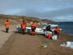
Archaeology, History and Archaeo-zoology: Background and plans for 2008/2009 Comprehensive archaeological sources from previous investigations around Clavering Island and from GeoArk’s pilot projects in 2003 and 2005 are at our disposal (e.g. Gulløv et al. 2004, Jakobsen et al. 2004, Jakobsen in prep., Jensen in prep.). Furthermore, information from recent surveys and excavations carried out by GeoArk during the summer of 2007 will be integrated in the careful planning of our current analyses and investigations in the Young Sound/Clavering Island/Wollaston Forland area in 2008.
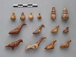
Re-analyses of artefacts and faunal materials from earlier expeditions, e.g. Lauge Koch's Three Year Expedition, 1930-32, during which a significant number of Thule Culture winter houses were excavated by Helge Larsen, are in progress at the national museums in Denmark and Greenland and at the Natural History Museum of Denmark. Supplemented by a series of new AMS-datings on artefacts and terrestrial fauna this 'old' material is re-activated and utilised by the GeoArk-project in order to elucidate Thule Culture chronology, hunting technology, material culture changes and subsistence.
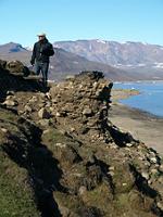
The planned fieldwork, summer 2008, includes excavations of well preserved midden layers on winter sites, but in accordance with the goals of GeoArk, it is important to gain knowledge on the entire Thule settlement and subsistence pattern in the study area. Thus, in depth investigations of spring-, summer- and autumn-sites in different ecological zones will be conducted in 2008. The Thule site on Hvalros Ø (registered by GeoArk in 2005), is selected for detailed investigations as a representative of the huge assemblage camps situated on the rough outer coasts of the study area; the Dahl's Skær, Kap Breusing and other summer sites containing dozens of tent rings and tent-houses along Clavering Island's south-east shore discovered by GeoArk in 2007, are selected as representing warm season fiord-sites; and finally, Moskusheimen on the main land west of Clavering Island, will be subject to detailed excavation. Moskusheimen provided access to inland game like caribou and musk oxen, and test pits in 2007 demonstrated that bones and other organic matter of Thule origin are preserved here in spite of heavy activities by 20th century hunters/trappers. In accordance with the interdisciplinary approach of the GeoArk-project these sites are, as well, selected due to their potential for palaeo-environmental studies (see below).
The archaeo-zoological component of GeoArk aims at uncovering the dynamics of the living resources in the study area around Clavering Island/Young Sound. The annual cycle of the hunting groups, their migrations and long-term subsistence strategies are closely linked to the occurrence, frequency and availability of the game animals. Information from bone materials retrieved during previous excavations is currently being combined with faunal data from GeoArk’s recent investigations in 2007. In particular the winter site of Fladstrand provided well preserved bones encapsulated in turf layers. Accordingly, further excavations will be carried out here in 2008. In contrast, some of the large summer sites, e.g. Kap Breusing, show very low sedimentation rates and sparse vegetation. Consequently, animal bones and artefacts lye on the surface, and in certain places they form undisturbed 'snap shots' of summer life and subsistence at the site. In 2008 a couple of these sites will be investigated in order to provide us – for the first time - with detailed knowledge about exploitation patterns on seasonal sites.
Information from recent monitoring of the fauna in North East Greenland, palaeo-ecological data on vegetation and fauna as well as historic sources from European commercial large scale whaling and sealing in the Greenland Sea are being compiled, and comparative analyses between different regions of North East and East Greenland will be carried out.
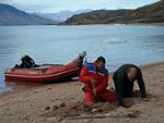
Finally, soil samples from culture layers were taken in 2007 in order to test for ancient DNA of fauna and flora in the sediments. This might open new avenues to subsistence analyses at High Arctic sites, where bones are only sporadically preserved. The results of these tests will be incorporated in the planning of the coming field season. The ultimate goal is to gain a holistic understanding of developments in climate, environment and culture of Northeast Greenland. Besides being an integral part of the GeoArk-project, the archaeo-zoological component is also an initial step in a study of the environmental history of the Gulf Stream and its impact on human societies of the North Atlantic during the Holocene.
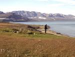
Physical Geography and Marine Ecology: background information and perspectives for 2008/2009 The physical environment, including the quantity of the natural resources and human access to them, is influenced by cyclic as well as chaotic climatic changes. In addition, snow coverage on land and sea ice coverage affected the necessary communication and travelling in relation to Inuit societies. Therefore, GeoArk’s studies of the natural history and physical geography in the area focus on the late Holocene and on the environmental dynamics in coastal landscapes and near coastal waters during the ‘cultural era’ of North East Greenland.
Recent studies of the environment reveal that the physical geography and biology of the ice-free landscape, fjords, and coastal waters are closely linked to the estuarine circulation. This circulation depends on land/ocean exchanges and interactions. The ice and open water/polynia dynamics close to the coastal landscapes is determined by both the climatic sensitive run off from land and the impact of and input from oceanic and atmospheric circulation to the area.
A preliminary outline of the Holocene environmental variability is based on knowledge on the local Young Sound area. In addition, existing information about geomorphology and palaeo-biology from central East Greenland is being compiled and used to provide a general framework for the understanding of the coastal landscapes and their dynamics. Modern environmental data series including weather station records and satellite data are used to assess present variability and dynamics in snow and ice coverage.
Detailed mappings and descriptions of erosion and accumulation patterns due to geomorphological processes in coastal, lagoonal, lacustrian and nivation landscapes were made at selected sites during the earlier field seasons. Data on fossil soils, nivation sediments and sediments in lakes and lagoons were gathered on sites along the south coast of Clavering Island in 2007, including cores from lakes close to Thule settlements. The cores are now being analysed. Furthermore, soil samples from excavations of the turf covered culture layers at Fladstrand were taken in order to correlate archaeological and geomorphological phases at the site. Detailed planning of the 2008-field season is depending on the results of these analyses. However, it is clear that 2008-field activities must include detailed geomorphological studies and supplementary corings of small lakes, beach ridges and lagoons at Hvalros Ø/Sabine Ø and at key sites along the formerly settled south coast of Clavering Island. Likewise, in accordance with the archaeological/zoological priorities, the vicinity of the 'inland' site Moskusheimen will be subject to palaeo-environmental studies.
The 2008-campaign is planned to include an important new activity: In collaboration with Canadian colleagues high-resolution sediment cores are extracted from the Young Sound Estuary and along the outer coasts of the study area. The cores will be dated and analyzed for biotic and abiotic palaeo-environmental signals. Present hydrographical conditions, estuarine circulation, sediment distribution, and open water area dynamics will be recorded. This international collaboration facilitates access to advanced analyses of the bottom sediments, and thus we are aiming at describing changes in estuarine processes, land/ocean interactions, and ice coverage of the sea with a special emphasis on polynia formation and variability during the late Holocene.
New methods The GeoArk-project includes development and test of new methods: the sampling for ancient DNA in the culture layers has been mentioned above, but also luminescence (OSL) dating of Thule dwellings and beach ridges is tested in order to pave the way to high resolution chronologies at sites with no organic preservation. In 2007 OSL-samples were taken at the Dahl’s Skær site on south Clavering Island. These are currently being analysed, and, depending on the outcome of this pilot project, more OSL samples i.a. at Hvalros Ø will be taken in 2008.
Participants, organization and collaboration partners
The GeoArk-project is directed by senior researcher Bjarne Grønnow, SILA. The archaeological research is conducted by Bjarne Grønnow, professor Hans Christian Gulløv and post.doc Mikkel Sørensen. Ass professors Bjarne Holm Jakobsen, Aart Kroon and post.doc Jørn Torp Pedersen are responsible for the physical geographical and marine ecological research activities.
The zoologists, professor Morten Meldgaard and post. doc Anne Birgitte Gotfredsen are in charge of the zoological research.
The post. doc's are forming a separate working group, concerning research, publication and general organization, within the project
GeoArk's collaboration partners are: National Environmental Research Institute (University of Aarhus), The Greenland Institute of Natural Resources (contact: professor Søren Rysgaard), Danish Polar Center, The Royal Danish Geographical Society, Dept. of Geography (University of Toronto, Canada (contact: professor Joe R. Desloges)), Dept. of Anthropology (University of Toronto, Canada (contact: ass. professor Max Friesen)), and Avataq Cultural Institute (Montreal, Canada (contact: head of centre Daniel Gendron)). In addition, every researcher in GeoArk is participating in comprehensive international networks.
Publications
Bennike, O., M. Sørensen, et al. (2008). Late Quaternary Environmental and Cultural Changes in the Wollaston Forland Region, Northeast Greenland (chapter 3). Arctic Climate and Climate Change with a Focus on Greenland. In: (eds): High-Arctic Ecosystem Dynamics in a Changing Climate. - Advances in Ecological Research, Vol. 40, 45–76, Elsevier, New York. H. Meltofte, T. R. Christensen, B. Elberling, M. C. Forchhammer and M. Rasch.
Jakobsen, B.H.; Andreasen, C.; Sørensen, M.P. and Møller, H.S. (2004): Kyst, menneske og miljø i fjordene ved Clavering Ø og Wollaston Forland i Østgrønland. Ekspeditionsrapport 120 p., Nationalmuseet og Det Kongelige Danske Geografiske Selskab.
Jakobsen, B.H. et al., (in prep): GeoArk 2007. Report on geographical fieldwork on Clavering Island, North East Greenland. SILA Feltrapport.
Jakobsen, B.H (2008). Kyst, mennesker og miljø i Nordøstgrønland.
Jensen, J. Fog et al., (2008): GeoArk 2007. Rapport over rekognosceringer i Nordøstgrønland. SILA Feltrapport nr. 27.
Sørensen, M. and C. Andreasen (2006). "Geo-Ark 2003". Arkæologisk berejsning af: Wollaston Forland, Nordlige Clavering Ø, Sydspidsen af Kuhn Ø. SILA-Feltrapport nr 23. København, Nationalmuseet København, Grønlands Nationalmuseum og Arkiv.