
The GeoArk 2008 expedition to North East Greenland
Fieldwork
.")
.")
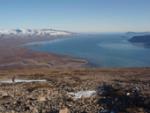
Surveys and excavations were carried out on Clavering Ø (Clavering Island) and Sabine and Hvalros Ø (Walrus Island) 74º to 74º 30’ North during the period 25th July to 3rd September.
The team members were archaeologists Bjarne Grønnow (director of the project), Hans Christian Gulløv, Mikkel Sørensen (SILA, the National Museum of Denmark) and archaeologist student Mariane Hardenberg (University of Greenland), geographers Bjarne Holm Jakobsen, Art Kroon and Jørn Bjarke Torp Petersen (Institute of Geography and Geology, University of Copenhagen) and zoologist Anne Birgitte Gotfredsen (National History Museum of Denmark, University of Copenhagen). The project “The Battle of the Climate” by archaeologist Jens Fog Jensen, SILA and historian Tilo Krause, Roskilde University shared logistics with GeoArk.
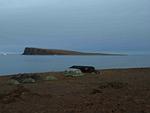
The first base camp was established 25th July on the south coast of Clavering Ø at Eskimonæs with logistic assistance from Zackenberg Ecological Research Operation. The 10th of August the base camp was moved to Sabine Ø off Wollaston Forland by the kind assistance of the vessel Aage V. Jensen from Daneborg in Young Sund. The 22nd August all gods and personnel were transported back to Daneborg kindly assisted by the Sirius Patrol, Daneborg.
Archaeology

The main objectives were to explore the settlement patterns of the Thule Culture from the initial settlers arrived to the region at the beginning of the 15th century AD until their disappearance c. 1850 AD. Paleo-Eskimo remains e.g., lithic artefact and midpassage ruins of the Independence I (c. 2.500–1900 BC) and Greenlandic Dorset (c. 800–0 BC) were also registered, and apparently they concentrated at the same ‘hot spots' as the Neo-Eskimo structures.
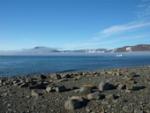
In the inland area near Moskusheimen and the western part of Clavering Ø scarce numbers of Thule tent rings and hunting beds were documented. In the mid fjord region at the south coast of Clavering Ø selected sites, documented in 2007, were revisited. Thule tent rings at Eskimonæs and Holmevig were excavated and the huge Dødemandsbugten and another large winter site Eskimovig were revisited for further examination and systematic GPS mapping. At the winter habitation Fladstrand extensive excavations of midden deposits were carried out. At the outer coast we focused on seasonal sites situated on small islands and promontories facing Grønlandshavet (Greenland Sea). Hvalros Ø, a tiny island with series of raised boulder beaches, briefly visited in 2005, exceeded our wildest expectations. This huge seasonal gathering site with hundreds of Thule tent rings, robust dwellings, large meat caches and massive boulder walls built as protection against the prevailing northerly and southerly winds was systematically registered and GPS mapped.
Miniature playing houses resembling the exact design, roughly to the ground plan, of Thule winter dwellings were examined. Thirty three playing house formations on Clavering Ø, Wollaston Forland, Sabine Island, and Walrus Island were sketched out in detail. Certain generalisations for the description of similarities among the recovered playing house could be allowed. Amongst these were the arrangements of brightly coloured white and red pebbles clearly depicting the meat and blubber caches in miniature formations. These miniature houses were typically situated in the near vicinity of summer settlements.
Zoology
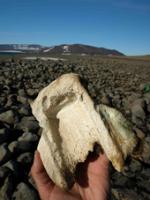
The excavation at Fladstrand produced thousands of animal bones. The identification of separate strata now provide optimal possibilities for examining the exploitation pattern of natural resources over time in the mid fjord region. The inland Thule structures yielded few bones which were either collected or surface registered and on Hvalros Ø animal remains were surface registered and bones for dating were sampled.
The Thule population was highly mobile with a flexible economy utilising both terrestrial game, as documented by numerous remains of caribou but with marine mammals as the corner stone of the economy. The Thule people used the land and seascape in a yearly cycle with primarily caribou and goose hunting inland. The mid fjord winter habitations shoved dominance of seals, especially ringed seal, narwhal, bowhead whale and to some extent walrus. However, new information gained from the 2008 observations on Hvalros Ø underline the importance of this huge gathering site for the processing and storing of meat and blubber from walrus. The large outer coast aggregation sites are located where the ice breaks up early and the sea ice openings have land contact. It may have been of vital importance for the survival of the Thule population in the region to have this early spring access to polynias.
Geography
Coastal settlements in various morphological settings were visited and described, like pocket beaches with actual and Holocene beach ridges between headlands at Clavering Ø, gravel spits and lagoons on Hvalros Ø, and the present day delta of Zackenberg on Wollaston Foreland. Levelling surveys and echosoundings were made to quantify the dimensions of the morphological features at land and on sea, to reconstruct beach ridge positions and to map the old and present day shorelines. These data were used to study spatial and temporal variability in erosion and accumulation patterns along the shores. Besides, they were used together with maps of solifluction lobes and other dynamic periglacial features, to understand recent changes in and around the settlements.
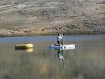
The sedimentary history of small basins like lagoons, lakes and nivation niches was studied to reconstruct variations in climatic parameters, such as the general temperature, especially during the summer, the snow cover, and the ice thickness in the coastal waters. Cores were taken in shallow bottom frozen lakes (in winter) near Revet, and in deep non-bottom frozen lakes at Eskimonæs and at Germania Havn on Sabine Ø. The cores were further analyzed and dated in the laboratory with e.g. XRF scanning. Fossil soils were sampled in the field on sites along the south coast of Clavering Ø near e.g. Eskimonæs in order to correlate archaeological and geomorphological phases at the sites. Additional cores were taken on the seaward slope of the Clavering Sound off Hvalros Ø close to the location of a polynia with the help of the Danish Marine vessel ‘Vædderen’. These cores will also be used to study the climate conditions over the Holocene in further detail.
By Anne Birgitte Gotfredsen (ed.) November 2008.