
The GeoArk 2007 expedition to North East Greenland
Fieldwork
.")
.")
The field work with surveys and trial excavations was carried out primarily on Clavering Ø (Clavering Island), North East Greenland during the period 31st July to 28th August.
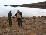
The team members during the GeoArk 2007 field season were archaeologists Bjarne Grønnow (director of the project) and Jens Fog Jensen (SILA, the National Museum of Denmark), geographers Bjarne Holm Jakobsen and Art Kroon (Institute of Geography and Geology, University of Copenhagen) and zoologists Anne Birgitte Gotfredsen and Morten Meldgaard (National History Museum, University of Copenhagen).
The first base camp was established 1st August on the south coast of Clavering Ø at Eskimonæs with logistic assistance from Zackenberg Ecological Research Operation and the vessel Aage V. Jensen from Daneborg in Young Sund. The base camp was moved to Dahls Skær closer to the outer coast 14th August. The 23rd of August all gods and personnel were transported back to Daneborg kindly assisted by the Sirius Patrol, Daneborg by the vessel M/S Martha.
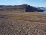
The focal area of research was the south coast of Clavering Ø from the inner narrow strait at Revet in west to Kap Breusing at the outer coast in northeast, Finsch Øer (Finsch Islands) and Kalven (The Calf) in Gael Hamke Bugt. Furthermore a few sites in Young Sound on the northern slopes of Clavering Ø and at the mainland near Zackenberg were visited and documented. The reconnaissance was performed from zodiacs with frequent landings and long stretches of coast were surveyed by foot.
Archaeology
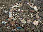
During GeoArk 2007 the main focus was on the Neo-Eskimo Thule Culture (c. 1400-1850 AD). However, Palaeo-Eskimo remains were also registered during the 2007 expedition. Lithic artefacts and settlement structures, e.g. midpassage ruins, from the Independence I (c. 2.500 – 1900 BC) and Greenlandic Dorset (c. 800-0 BC) were found, confirming observations made during the 2003 and 2005 field seasons.
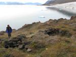
The southeast beaches of Clavering Ø, from Eskimonæs to Dødemandsbugten, are characterized by granite capes and many small bays providing protection against rough weather, often these locations have relatively lush vegetation. Thule winter houses built of a combination of stone and turf are here found in small groups and tent rings are situated at capes near by. A site situated at southern Clavering Ø, i.e. Dødemandsbugten, yields evidence of 43 Thule winter houses. This site is the largest Thule settlement in Northeast Greenland and it must be understood as a key site to the understanding of the Thule Culture in the area as well as in Northeast Greenland. The site yields substantial information about Thule Culture landscape use, economy, history and cultural development.
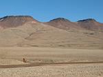
The outer coasts of Clavering Ø and Wollaston Forland are characterized by eroding sedimentary rocks and large areas with creeping soil intersected by basalt capes where some characteristic large seasonal sites are located with dozens of tent rings, shelters and meat caches and in several cases with two winter houses built together. The winter houses are here constructed almost entirely of flat basalt stones and very little turf. These sites may have been visited at all times of year.
From previous expeditions to the Clavering Ø area the majority of winter houses were known but for the first time the GeoArk 2007 expedition documented the large tent sites at the outer coasts on sketch maps and by systematic GPS mapping.
Geography
The geographers of the team were focused on the coastal areas where the settlements were found and they tried to reconstruct climate conditions of the area over the last centuries. The coastal morphology of the south and east coast of Clavering showed pocket beaches with actual and recent beach ridges between basaltic headlands, alternated with small deltas. Levelling surveys were made to quantify its dimensions and to reconstruct beach ridge positions and old shorelines. These data were also used to study spatial and temporal variability in erosion and accumulation patterns along the shores. Locations with recent periglacial processes around the settlements were mapped.
The climate conditions of the area largely influenced the availability and accessibility of natural resources to the Eskimo population. The sedimentary history of small basins like lagoons, lakes and nivation niches was studied to reconstruct variations in climatic parameters. These parameters included the general temperature, especially of the summer, the snow cover, and the ice thickness in the coastal waters. Field samples of fossil soils were sampled on sites along the south coast of Clavering Ø, including cores from lakes at Eskimonæs and from the hinterland near Dahls Skær. These samples were further analyzed and dated in the laboratory. Soil samples from excavations at Fladstrand were gathered in order to correlate archaeological and geomorphological phases at the site.
Zoology
In order to collect data on the natural resources, surface registration was carried out at three huge seasonal sites. Due to the sparse vegetation layer, animal bones were visible on the soil surface scattered in and around the Thule features and due to low precipitation they have survived for centuries. Two Thule sites were selected for trial excavations; Fladstrand mid fjord produced well preserved faunal remains and at the ‘inland’ site Moskusheimen well preserved bones were retrieved from test pits.
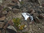
Bones of ringed seal occurred at numerous sites while the large sea mammals, narwhal and walrus were found primarily on the mid fjord and the outer coast sites. One site showed to be a kill site for bowhead whales with several vertebrae and limb bones lying scattered in the erosion horizon. Caribou remains occurred frequently both as marrow fractured bones in association with the archaeological structures and as cadavers from some of the last representatives of the East Greenland caribou population which went extinct at the turn of the 19th century. From the archaeological evidence it seems that terrestrial game, both musk oxen and caribou, played quite an important role for the Thule people in the Clavering Ø region.
By Anne Birgitte Gotfredsen, May 2008.