The GeoArk 2005 expedition to North East Greenland
Fieldwork
During August 15th –28th, 2005, fieldwork was carried out in a coastal area off the Wollaston Forland in North East Greenland. The Geo-Ark 2005 expedition was the second and last phase of a geographical/archaeological pilot project organized as a joint venture between the Greenland National Museum & Archive, SILA and The Institute of Geography, University of Copenhagen.
The aim of the pilot project was to enlighten the potential for a future 3-5 year interdisciplinary project focusing on the cultural history and the interplay between man and coastal landscapes and resources in a High Arctic environment.
Headed by Bjarne Holm Jakobsen (The Institute of Geography) the team members were Bjarne Grønnow (SILA), Henrik S. Møller (The Institute of Geography) and Robert Gilbert (Queens University, Canada).
As the expedition in 2003 mainly surveyed the coasts along Wollaston Forland and thus the straits bordering Clavering Ø and Kuhn Ø, the research area of Geo-Ark 2005 was concentrated on a typical outer coast area.
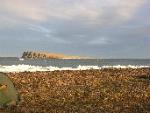
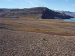
The expedition profited from the logistics of the Zackenberg research station and the head quarters of the Sirius Patrol, Daneborg, in Young Sound. We established base camp at Germania Havn on the southern shore of Sabine Ø, where we stayed in a fur hunters’ cabin from the first half of the 20th century. Surveys were mainly limited to the two peninsulas sheltering the natural harbour, Germania Havn (Germania Harbour), and to Hvalros Ø (Walrus Island), a small island situated as a huge ‘ice breaker’ about 4 kilometres SSE of Germania Havn.
Archaeology
Traces of a 4.500 year long, discontinuous culture history was found during the ten days of surveys in the area. Dwellings and caches of the different periods were found more or less on top of each other, which means that even if several centuries separated the different human settlement episodes, concentrations of different marine hunting game occurred exactly at the same ‘hot-spots’ along the coasts during the late holozene.
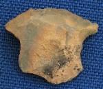
Traces of the earliest Paleo-Eskimo culture in North East Greenland, Independence I (c. 2.500 – 1800 BC) and the Greenlandic Dorset/Independence II (c. 800 – 400 BC) were found as lithic artefacts on the Thule Culture (c. 1400 – 1850 AD) sites and as a few undisturbed tent rings and mid passage dwellings in the fringe of the large Thule sites. Paleo-Eskimo traces were recorded at Observatory Peninsula, Vardenæs and Hvalros Ø.
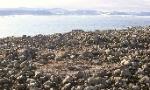
A small group of Thule winter houses was located on Observatory Peninsula, but otherwise the survey area was characterised by large ‘warm season’ settlements. These Thule culture settlements were found and sporadically described by D. McI. Johnson, member of the Cambridge East Greeenland Expedition, in 1926. However, it was certainly worthwhile to revisit these spring, summer and autumn settlements. We registered about 45 tent rings and dozens of meat caches and play houses on Vardenæs and Observatory Peninsula E and W of Germania Havn. No doubt, many more have existed, but frequent and heavy swells of the Denmark Strait are taking their toll of the sites. Coastal erosion is accelerating these years of changing drift ice conditions.
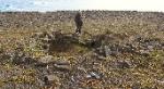
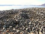
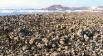
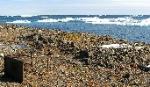
Hvalros Ø exceeded our greatest expectations: this 3 by 2 km island with its series of raised boulder beaches is practically one big Thule site. Due to drift ice conditions and bad weather we had to restrict our detailed registrations to the central west coast (Johnson’s Lake Colony), but surveys made it clear that an estimated number of 150 tent rings and tent houses and as many meat caches, shelters and other structures virtually ‘cover’ the entire west facing beach ridges of the island. Bones found on the site surface demonstrates that the large caches of this huge (spring)camp was once filled with meat from walrus and small whales (beluga and/or narwhal). The island is exposed to strong northern winds and thus the inhabitants constructed some massive walls to protect hunters waiting for the migrating sea mammals and to protect their tent houses. A large circular stone built structure (8-10 metres in diameter) on the upper part of the main settlement is interpreted as traces of a qassé, which is a festival or men’s house – the first of its kind from North East Greenland.
It is well known that the last representatives of the Thule Culture in North East Greenland was observed by Clavering in 1823, but more recent traces from several expeditions from the ‘golden era’ in the last part of 19th and the beginning of the 20th century are numerous in the area. E.g. the foundation of an observatory (from the Sabine or Koldeway expeditions of the 19th century) and a huge cache left for Sverdrup on Hvalros Ø by the Swedish explorer Nathorst in 1899 were located. Finally the fur trappers and seal hunters from Danish and Norwegian companies from the first half of the 20th century has left their roofing felt covered cabins - and their garbage - on promontories and islands all along the coasts. At present some of the cabins are used and maintained by the Sirius Patrol.
Geography
Apart from doing surveys, the geographers of the team concentrated on coastal morphology and late holocene landscape formation processes. Borings were made in the lake deposits near Germania Havn and in a small lake at Hvalros Ø. Hopefully the analyses of the sediment cores add valuable information about the changing High Arctic environment during the late holocene.
All data are now being processed and a report covering the entire pilot project (Geo-Ark 2003 and 2005) is being prepared for the Report series of the Danish Polar Center.
By Bjarne Grønnow, October 2005.